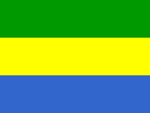
Gabon
Immigration No. 2 on passport fraud
Gabon kicks off Senate elections
We will shock Senegal-Coach Pa Suwareh Faye
GABON: Negotiations underway to resolve teacher strike
GABON: Negotiations underway to resolve teacher strike
Gabon oil investments get "go ahead"
National name: République Gabonaise
Geography
Capital: Libreville
Major Towns: Lastoursville, Kango, Port-Gentil, Mayumba
Location (geographical coordinates/latitude and longitude): 0°23'N, 9°27'E
Time Zone: WAT (UTC+1)
Size (Land and Sea): 267,667 sq km
Borders with Cameroon 298 km, Republic of the Congo 1,903 km, Equatorial Guinea 350 km
Elevation extremes: Lowest point: Atlantic Ocean 0 m; Highest point: Mont Iboundji 1,575 m
Politics
Head of State: President: El Hadj Omar Bongo Ondimba (1967), Premier: Jean Eyeghe Ndong (2006)
Form of Government: Republic
Independancy (from France): August 17 1960
Currency: CFA franc (XAF)
Industry
Main industries: Petroleum extraction and refining; manganese, gold; chemicals, ship repair, food and beverages, textiles, lumbering and plywood, cement
Natural Resources: Petroleu, natural gas, diamond, niobium, managanese, uranium, gold, timber, iron ore, hydropower
Agriculture: Cocoa, coffee, sugar, palm oil, rubber, fish
Population and People
Population: 1,454,867
Population density per sq mi: 15
Growth rate: 2.0%
Birth rate: 35.96 births/1,000 population (2007 est.)
Total fertility rate: 4.71 children born/woman (2007 est.)
Infant mortality rate: 53.7/1000
Religion: Christian 55%-75%, animist, Muslim less than 1%
Languages: French (official), Fang, Myene, Nzebi, Bapounou/Eschira, Bandjabi
Ethnic groups / Tribes: Bantu tribes, including four major tribal groupings (Fang, Bapounou, Nzebi, Obamba); other Africans and Europeans, 154,000, including 10,700 French and 11,000 persons of dual nationality
Average age: 0-14 years: 42.1% (male 307,444/female 305,468); 15-64 years: 53.9% (male 391,194/female 393,103); 65 years and over: 4% (male 23,978/female 33,680) (2007 est.)
Life expectancy: 54.0
Literacy (definition: age 15 and over can read and write): Total population: 63.2%; male: 73.7%; female: 53.3% (1995 est.)
- Vast sprawl of virgin rainforests
- Teeming wildlife
- Spectacular Cirque de Léconi, a deep, circular red-rock canyon of loose sands
- Mayumba: endless and uninhabited beaches, whales spouting in the distance, trees full of magical spirits, and nesting sea turtles on the beach
- Réserve de la Lopé: most accessible and most popular wildlife with elephants, buffalo, gorillas and a variety of other primates
- 800km long sandy coastal strip is a series of palm-fringed bays, lagoons and estuaries
- Lush tropical vegetation
- The nation's name originates from these days as 'Gabão' is Portuguese for cabin, which is roughly the shape of estray by Libreville
- Rainforests covering 85% of the country
- Gabon's largest river is the Ogooué is 1200 km long
- Gabon is also noted for efforts to preserve the natural environment
- Gabon is more prosperous than most nearby countries, with a per capita income of four times the average for Sub-Saharan Africa
- Gabon is rich in folklore and mythology
- Bantu people
- Stunning white beaches
- An abundance of wildlife, including gorillas, panthers, parrots and elephants
- Libreville: charming and cosmopolitan oceanside capital with National Museum, Presidential Palace (costed US$800 million to build) hustle and bustle of the Mount Bouet Market
- The Cathedral of St Michael in Libreville is famous because of its 31 unusual wooden columns which were carved by a blind Gabonese craftsman; each of the columns depicts a Biblical scene.
- Lambaréné was made famous by Doctor Albert Schweitzer. Schweitzer Hospital is open to visitors as part of it has been made into a museum
- M’Bigou and Eteke are famous for their local crafts and gold mines
- Bateke Plateau or Lopé-Okanda Reserve, Gabon’s biggest park, offer a variety of wildlife, including forest elephants, buffalos, sitatunga, river hogs, gorillas, panthers, crocodiles, monkeys and parrots
- Between July and September up to 3,000 humpback whales can be seen near Mayumba when they travel
 Text Area - Gabon
 Content List - Gabon News

 Map - Gabon Map